
Recommended Geosites
Recommended geosites for each season are useful for visitors who wish to walk in the Tateyama Kurobe Geopark
Asahi Area
Jade Coast
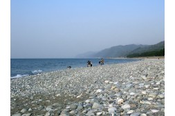
Jade Coast in Asahi Town
Here, you can collect gravel made up of serpentinite, tremolite rock, rodingite rock, psammitic-pelitic gneiss, jadeite rock, etc., which is supplied by the Omi-Renge Metamorphic Belt.
The Kurobegawa Fan Area
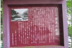
Japanese Cedar in the Stream at Sawasugi
Alluvial Fan Springs along the Toe of Kurobegawa Fan Geosite in Nyuzen Town
The Japanese cedars swamp at Sugisawa grow in colonies near the seashore and are considered rare vegetation. Because of this, they were designated as a national natural treasure in 1973.
At one time, the Japanese cedar swamp and the mixed woods grew at the alluvial-fan springs along the toe of Kurobegawa Fan.
Spring water at Sawasugi was designated as ‘100 the Best Water in Japan’ by the Ministry of the Environment in 1985.
45 hectares of the Japanese cedars swamp was reduced to 2.7 hectares by agricultural land development for a decade beginning in 1955.
Spring water called Shozu “Clean Water” at Ikuji
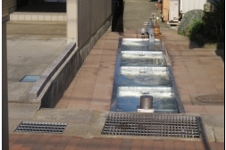
Alluvial Fan Springs along the Toe of Kurobegawa Fan Geosite in Kurobe City
Spring water called Shozu, or “Clean Water”, wells up in the town of Ikuji and occasionally in Kurobe City. Residents keep the wells clean and use them as a common washing place.
Famous “Clean Waters” include the ‘Shimizu-an clean water’ a photo of which is included above.
Takase Spring Water Garden
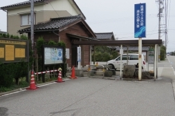
Alluvial Fan Springs along the Toe of Kurobegawa Fan Geosite in
Nyuzen Town
Spring water here was designated as 100 the Best Water in Japan by the Ministry of the Environment in 1985.
Spring water wells up at two places on both sides of the prefectural road; groundwater occurs at a depth between 38 and 40 meters.
Even people from outside of the Toyama Prefecture visit here to collect the water and bring it back home.
Nizayama Forest Art Museum
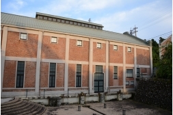
Funamino Geosite in Nyuzen Town
This art museum was repurposed from the low-head power plant, which was built in 1926, and opened in April of 1995. This was designated as a national registered tangible cultural property in December of 1996.
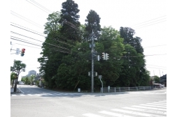
Aimoto Bridge
Top of Kurobegawa Fan Geosite in Kurobe City
The present Aimoto Bridge was rebuilt with steel after it was destroyed by a flood in August of 1969.
The previous Aimoto Bridge was built 60 meters upstream from the present bridge and was located where the Kurobe River is the narrowest.
The first Aimoto Bridge was built in 1626. In 1661 the Aimoto Bridge was rebuilt without a pier by the fifth feudal lord, Maeda Tsunanori, and became famous as one of the best three unusual bridges in Japan. The present Aimoto Bridge is the thirteenth best unusual bridge.
Kurobe George Area
Babadani
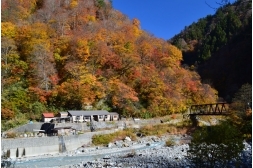
Keyakidaida Geosite in Kurobe City
The Babadani hot spring, a little-known hot spring, is located at the junction of the Baba Valley and the Jiji Valley. It is an open-feeling, outdoor hot spring; the water quality is that of a simple sulfur spring. And Babadani-jigoku (hell) is located upstream and hot spring swells at the river beach.
Mountain climbers going to Mt. Hakubadake and Mt. Karamatsu often stay at the Babadani hot spring.
Katakai River, Hayatsuki River Area
Ento-Bunsui Water Diversion Facility at Higashiyama
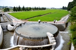
Katakaigawa Fan Geosite in Uozu City
Water shortages occur easily on the alluvial fan. This device was developed to distribute water in a fair manner.
Buried Forest in Uozu
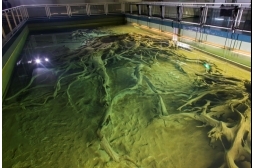
Katakaigawa Fan Geosite in Uozu City
This area near the seashore in Uozu city was covered with Japanese cedars about 2,000 years ago.
The status of the forest at that time was discovered by investigating the large roots of Japanese cedars, seeds, pollen and so on.
Namerikawa Citizen Exchange Plaza
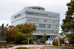
Katakaigawa Fan Geosite in Namerikawa City
You can enjoy views of the Tateyama Range and Toyama Bay from the roof of this building.
You can also observe an old alluvial fan by using a paid telescope also located there.
Old Japanese Cedar Dousugi
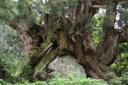
Katakaigawa Fan Geosite in Uozu City
Japanese cedars grow in colonies in Minamimata Valley along the Katakai River.
Old Japanese Cedar Dousugi also grow on big rolling rocks. Branches diverge and curve due to the weight of heavy snowfall. This area is generally composed of Augen Gneiss, but these rolling rocks are also composed of granite that came from a mountain several kilometers upstream. They are assumed to be formed by sediment.
In addition to old Japanese cedar, epiphytic ferns grow on rolling rocks. Both of these growths are designated as the natural treasure of Uozu City.
Kamiichi River, Shiraiwa River Area
Ancient Tomb of Takenouchitenjindo
Shiraiwa River Geosite
This is a circular ancient tomb with a rectangular frontage that was built on level ground in the early Tumulus period (around the fourth century). It is 38 meters long.
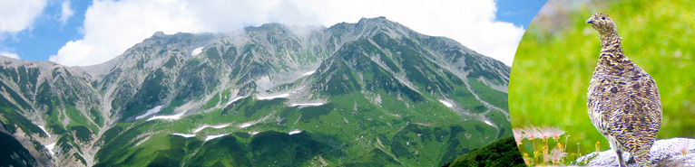
Mt. Tateyama Area
Mt. Oyama
Mt. Tateyama, Mt. Tsurugidake Geosite in Tateyama Town
Mt. Oyama is a 3,003 meters high, rocky mountain. The shrine is built at the top. Many people climb Mt. Oyama for worship and climbing every year.
The complex around the top of the mountain is intrusive rock of Ariake Granite, which was formed between 60 and 100 million years ago.
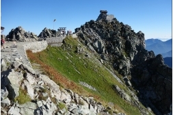
Murododaira
Murododaira Geosite in Tateyama Town
This is the lava plateau formed by an outflow of lava from a crater that existed in the Tateyama Caldera. The last eruption was 40,000 years ago. After that, magmatophreatic explosions continued on and around the lava plateau and formed the Mikurigaike and Midorigaike ponds.
Geothermal activities like hot springs and fumarolic activity can be observed in Jigokudani (Hell Valley).
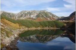
Midagahara
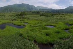
Midagahara Geosite in Tateyama Town
Midagahara is a 12 kilometers long welded tuff plateau formed by volcanic activity about 100,000 years ago. There are about 1,000 ponds on the eastern portion of the Midagahara Plateau and this area was designated as a Ramsar Site in 2012. The western area of the Midagahara Plateau is covered with Tateyama cedars and beeches.
Toyama Plain Area
Toyama City Sightseeing Tower
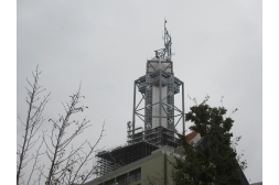
Toe of Jyoganjigawa Fan Geosite in Toyama City
You can enjoy views of the Tateyama Mountains, Toyama Bay, Toyama Plain and so on from the Toyama City sightseeing tower, which is 70 meters high. This is the best public place for scenic views in Toyama City.
The Big Rolling Stone at Oba
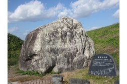
The Central of Jyoganjigawa Fan Geosite in Toyama City
The big rolling stone at Oba was carried there by a debris flow caused by the Hietsu earthquake in 1858.
The spring water of the Life-Prolonging Statue at the town of Isikura
The toe of Jyoganjigawa Fan geosite in Toyama city
This spring water swells on the side of the Itachi River.
It is believed to be miraculous water that is effective in healing all ailments. Many people visit here to collect the water and bring it home with them.
It was designated as ‘100 the Best Water in the Heisei period in Japan’ by the Ministry of the Environment and was also designated as the best water in the Toyama Prefecture.
Toyama Bay Area
Mirage View
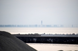
Mirage and Firefly Squid Geosite
The seashore in Uozu became famous for mirages in the Edo period (1603-1868).
Mirages can be seen mainly in April and May.
Mirages can occur by the refraction of solar rays when warm air is in the upper zone and cold air is in the lower zone just above the sea.
You can view an exhibition and a high-definition movie about mirages in the Uozu Buried Forest Museum.